

Glenwood Canyon I-70 closure wreaks havoc on travel and the economy
Fires, mudslides and the extended closure of Interstate 70 through Glenwood Canyon have created a perfect storm of economic and transportation problems for western Colorado that are likely to reverberate for years.
The disruptions to travel, supply lines, drops in tourism bookings, deliveries of gasoline, food and merchandise and problems caused by people unfamiliar with the area trying to navigate around the closure have added to the already-strained emergency response assets and frayed pretty much everybody’s tempers.
Hardest hit by economic and traffic woes are the towns along the Roaring Fork Valley from Aspen to Glenwood Springs and workers who have to commute over Cottonwood Pass between Gypsum and Glenwood Springs to get to and from work.
Gregg Macaluso, an?adjunct professor at the?University of Colorado Leeds School of Business?who teaches supply chain strategy and innovation, said the closure of one of only five major east-west interstate shipping routes magnified supply chain problems that were already impacted by an ongoing shortage of truck drivers and by the COVID-19 pandemic that have been affecting supply chains not only locally, but nationally for several years.
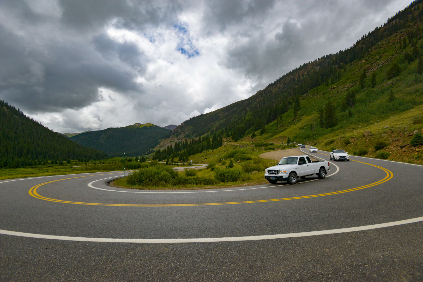
On July 29 and again on Aug. 1, unprecedented monsoon rains dumped as much as 4 inches of rain in an hour on the Grizzly Creek burn scar, causing multiple mudslides. At Blue Gulch the rainwater gathering more than 3,400 feet above the canyon floor soared over a 200-foot cliff half a mile north of I-70 and poured into the ravine below. When the cascade of mud and rock hit the highway, both upper and lower decks of the roadway were covered with up to 10 feet of debris.
The storms have been characterized as a “500-year event,” which means that climatologists calculate there is a 0.02% chance of an event of that magnitude every year.
On Monday, Gov. Jared Polis and Department of Transportation Director Shoshana Lew requested $116 million in disaster relief funds from the Federal Highway Administration to repair I-70, improve a bypass route and mitigate hazards on the slopes above the highway. The Federal Highway Administration responded Tuesday to the request, one business day later, with a grant of $11.6 million under its quick-release process, 10% of the total Polis requested.
Glenwood Springs, on the west end of the canyon, was cut off from easy access by travelers and tourists as well as suppliers, resulting in an overall business downturn with canceled reservations, empty hotel rooms and some empty shelves in stores.
Glenwood Springs Mayor John Godes says tourism has taken a huge hit, what with the fire closing the canyon last year, the COVID-19 pandemic and now the mudslides.
“I-70 is a major artery throughout the state, so statewide, region-wide, within our local region and the region of western states, it’s a very disruptive natural occurrence,” Godes said.
“It’s really, really hurt our economy,” he said. “Hotel rooms are vacant. The impact to the economy is very similar to the Grizzly Creek fire when it shut down I-70. Glenwood Springs was a ghost town. We rely on visitors, the local economy relies on that. Not having that ability to get people from the Front Range or wherever to be able to come out here to raft, to fly-fish, to soak in the hot springs, it’s really crippling for our economy.”
Godes wasn’t able to say precisely what the fiscal impact of this long-term closure might be, but he compared it to the fire that set up the situation the city is facing now.
“I do know that when the Grizzly Creek fire hit, in the middle of COVID, there was a lot of things that were going on, obviously, but it cratered our sales tax revenue by about 20%,” Godes said. “So any prolonged disruption of I-70 is just very difficult for us to get through.”
Godes said his expectations for the public stopping to spend money in Glenwood haven’t panned out, and the increase in traffic on Colorado Highway 82 caused by travelers using Independence Pass into Aspen haven’t helped much either.
“It’s devastating to our businesses to hear words like ‘severely damaged’ and ‘disaster,’ said Lisa Langer, director of tourism promotion for the Glenwood Springs Chamber of Commerce. “When we hear those words, it makes it sound like we’re not open, and Glenwood Springs is open and looking forward to greeting visitors.”
Langer said that before the mudslides, “We were actually running 30 to 40% over our figures, pretty much across the tourism spectrum, of 2019. We were doing really well this year.”
Inundated with shortcut traffic
In Aspen, legions of automobiles coming down from Independence Pass clog up East Cooper Avenue – as Highway 82 is known there – that runs through Aspen and down the valley to Glenwood Springs, passing through villages and towns including Basalt, El Jebel and Carbondale.
All that through traffic headed west to I-70 ends up in Glenwood, clogging its streets but not leaving much money behind in the process, Godes said.
“When the Grand Avenue Bridge was replaced in 2017, I was one of these optimistic people that thought all these commuters from Aspen are going to stop at our restaurants and just sit and wait for traffic to clear a little bit and then continue,” he said. “That did not happen. People stayed in their cars with their windows rolled up, their air conditioning on, their music playing and just gritted through it.”
Pitkin County Sheriff Joe DiSalvo is even less pleased with the traffic on Independence Pass. He says the sheer volume of traffic trying to get around Glenwood Canyon, not to mention those who don’t pay attention to the many signs limiting vehicle length to 35 feet or less on the pass, are causing traffic jams, delays of up to 8 hours and serious safety problems. There are three narrow one-lane sections of the road near Aspen that catch large vehicle drivers unaware.
“The road is just not built for this kind of traffic,” DiSalvo said. “The other day we had a car on fire up on the pass and there was no way we could get a fire truck up there. Fortunately the car burned out without starting a forest fire.”
Getting any kind of emergency equipment up from Aspen to deal with accidents or illness has become a lengthy process. The alternative for emergency response is from Leadville, some 58 miles from Aspen.
It’s not all bad news
There are some winners on the CDOT-approved northern detour that takes drivers through Silverthorne, Steamboat Springs, Craig, Meeker and Rifle, a 220-mile, 4-hour detour.
Speaking of the detour, Macaluso said, “My estimate is that it’s not a big deal, but when you multiply it against the fact that there are less available drivers, there will be a ripple effect. It won’t be just the length of time of the detour. What that effect is is hard to gauge, it depends on the commodity and the circumstance, but it’s not trivial.”
Lindsay and Chris Dillenbeck, fifth-generation owners of Steamboat Springs’ iconic F.M. Light & Sons western clothing, boots and hat store, said all the traffic has been great for business.
“It’s too bad that everyone has to be rerouted and take this long detour, but we hope that while they do they get to enjoy some beautiful scenery and maybe stop in our town and get a taste of the Wild West, which is still here.”
Drivers on the detour are clogging up U.S. Highway 40, which is also Steamboat’s main drag, Lincoln Avenue, thanks to the 25 mph speed limit and numerous stoplights. Delays can be 30 minutes or more just to get through town.
As a result, unlike Glenwood, many people are taking a break and patronizing downtown businesses rather than sit in a seemingly endless line of semi-trucks, cars and RVs moving at a snail’s pace.
F.M. Light & Sons opened for business Nov. 9, 1905. Its iconic yellow and black signs along the highways leading into Steamboat can be seen as far as 50 miles out in all four directions. The signs were erected in the 1930s by Dillenbeck’s great-great grandfather, Clarence Light, and the Dillenbecks continue to maintain them.
“It’s our job. My husband and I go out and paint signs and fix them multiple times a year,” said Lindsay. “It’s still a family business and we’re working hard to maintain it.”
By keeping them in repair they maintain their right to have them, something now largely prohibited by the Lady Bird Johnson Highway Beautification Act of 1965, which prohibits most advertising signs and billboards along federally-funded highways like Route 40.
Further north, in Craig, the restaurants along Victory Way and Pershing Street, aka Route 40 and Colorado Highway 13, are also experiencing heavy traffic. But Dr. Chris Senseney, professor of civil engineering at the University of Colorado, says its streets, along with most of the roadways along the detour route, are not designed for this amount of heavy truck traffic, which will result in premature deterioration of the pavement that will be expensive to repair.
Speeding and improper passing are a big problem on the detour as well. While it’s not known how many traffic tickets have been issued, a worker at the Moffat County Public Safety Center, which houses the Moffat County Sheriff’s Office, Craig Police Department and Colorado State Patrol, said law enforcement has issued “a boatload of warnings.”
Down Colorado 13, according to Emily Mohr of the Meeker Chamber of Commerce, the “not too sleepy” town is even less enamored of the trucks and traffic, which makes it difficult at times to get across Market Street because there are no traffic lights, and drivers seem to think they don’t have to slow down through town.
Meeker is a recreational destination for off-road vehicle touring, fishing and camping in the summer, hunting in the fall and snowmobile excursions in the winter.
There’s not much drop-in tourism by impatient drivers frustrated by the 220-mile detour they’ve been forced onto, but once off Market Street, historic Main Street still enjoys plenty of bucolic small-town charm, with visitors willing to take a break being able to enjoy the shops and restaurants without the bustling crowds in Steamboat.
The western terminus of the northern detour is Rifle, where workers flag eastbound traffic diverted off I-70 at the West Rifle exit onto the Highway 13 bypass on the west side of town.
Only passenger vehicles and local delivery trucks headed for towns to the east such as Silt, Newcastle, Glenwood Springs and destinations up the Roaring Fork Valley like Carbondale and Aspen are allowed back onto I-70 eastbound.
CDOT is working hard to open up two-way traffic on the bottom deck as soon as possible, and Gov. Polis is requesting federal aid that will speed up the process. Until then traffic through the canyon will travel back to the 1970s, to a time when everyone had to slow down to 50 miles per hour and enjoy the scenery for 15 miles on what was once the last remaining segment of two-lane interstate highway in the nation.


Bennet, Hickenlooper to vote against Trump’s 10th Circuit nominee from Colorado
Michael Karlik
michael.karlik@coloradopolitics.com
Updated 6 hours ago
Colorado’s two Democratic senators will not vote to confirm President Donald Trump’s nominee to a vacancy on the Denver-based federal appeals court. Trump has selected U.S. District Court Chief Judge Daniel D. Domenico, who he appointed as a federal trial...
Who’s spending in Colorado to get your vote?
Marianne Goodland
marianne.goodland@coloradopolitics.com
Updated 2 hours ago
Groups that raise unlimited amounts of money have spent about $20 million in May and June to try and influence Colorado voters’ choices in the upcoming June 30 primaries. By law, these groups cannot coordinate with the candidates they support....
U.S. government declines to oppose multiple challenges to immigration detention in Colorado
Michael Karlik
michael.karlik@coloradopolitics.com
Updated 5 hours ago
Multiple federal judges in Colorado granted petitions from people challenging the lawfulness of their immigration detention this week after the government took the unusual step of declining to submit arguments in opposition. Colorado’s federal trial court is facing a flood of...
Tina Peters tells supporters to ‘stand up and fight back’ at Castle Rock event
Marissa Ventrelli
marissa.ventrelli@coloradopolitics.com
Updated 5 hours ago
Tina Peters, the former Mesa County clerk recently released from prison, warned supporters that what happened to her could happen to them, too, if they did not “stand up and fight back” at an event at the Douglas County Fairgrounds....
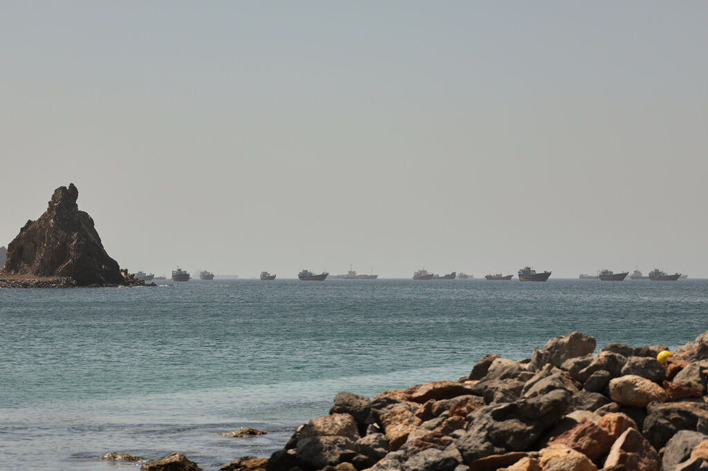
Iran strikes cargo ship in Strait of Hormuz, endangering Trump’s peace
Christian Datoc
christian-datoc@coloradopolitics.com
Updated 11 hours ago
Iran attacked a cargo ship traveling through the Strait of Hormuz on Thursday, possibly upending President Donald Trump‘s diplomatic end to the war with Iran. A U.S. official confirmed to the Washington Examiner that the Islamic Revolutionary Guard Corps “struck...

Senate GOP tries to mend fences with Trump after heated lunch
David Sivak
david-sivak@coloradopolitics.com
Updated 9 hours ago
Senate Republicans are trying to turn the page on a heated lunch with President Donald Trump that brought weeks of tensions to a new high-water mark. In a symbolic gesture, Senate Republicans took another vote on the Iran war Wednesday...
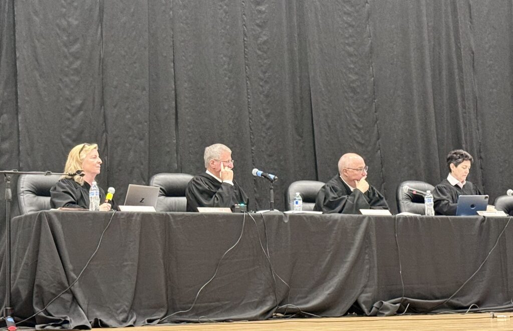
Colorado justices discuss solution to confusion from prior criminal ruling
Michael Karlik
michael.karlik@coloradopolitics.com
Updated 3 hours ago
The Colorado Supreme Court pondered the fallout on Tuesday from its nearly six-year-old decision interpreting the state’s impaired driving laws, with the justices now addressing how defendants affected by the legal change must seek postconviction relief. In contrast to other...
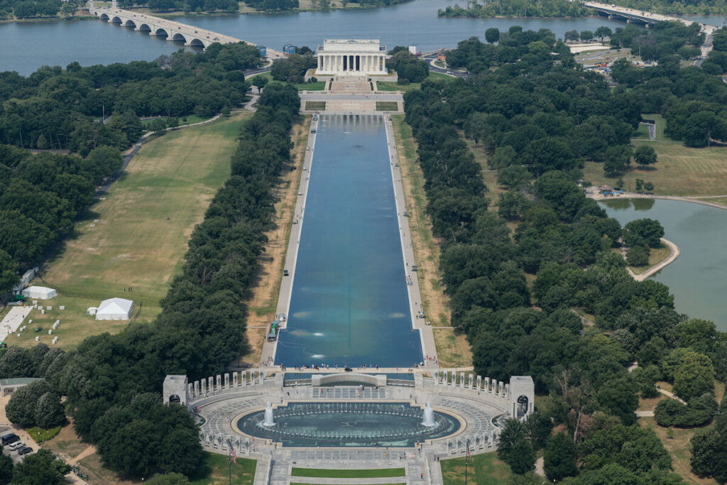
Colorado to participate in Great American State Fair in Washington
Marissa Ventrelli
marissa.ventrelli@coloradopolitics.com
Updated 9 hours ago
Visitors to Washington, D.C. for the country’s 250th anniversary will have the opportunity to learn about Colorado’s natural beauty and culture during the Great American State Fair, a World’s Fair-style event that opened Thursday at the National Mall. While all...
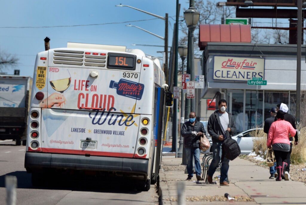
RTD to reconsider service priorities as cuts, budget deficit loom
Michael Braithwaite
michael.braithwaite@gazette.com
Updated 13 hours ago
Should the Regional Transportation District aim to maximize ridership or system coverage? That question sat at the heart of the RTD Board of Directors’ first Comprehensive Operations Analysis briefing on Thursday afternoon. With the Denver transit agency facing a budget...

Mobolade, Colorado Springs leaders say election date lawsuit is attack on local voters
Brennen Kauffman
brennen.kauffman@gazette.com
Updated 12 hours ago
Mayor Yemi Mobolade and other city leaders will fight to keep Colorado Springs elections in April in the face of a new lawsuit. Mobolade, the mayor’s Chief of Staff Wayne Williams and City Councilmember Roland Rainey addressed the lawsuit in...
PREV
PREVIOUS

10th Circuit reinstates First Amendment lawsuit of Muslim inmate forced to shave beard
Reversing a lower court’s ruling on Tuesday, the federal appeals court based in Colorado reinstated the lawsuit of a Muslim man against a state correctional officer for allegedly forcing him to shave his beard – despite a policy that allowed for beards as religious expression. A three-judge panel of the U.S. Court of Appeals for the […]

Mesa County Clerk Tina Peters slams Secretary of State's probe during appearance at symposium
Republican Mesa County Clerk Tina Peters isn’t responding to an order issued by Democratic Secretary of State Jena Griswold to turn over election equipment, video footage and documents after a password to county election equipment surfaced online. She may not be speaking to Griswold or responding to requests for comment, but that doesn’t mean Peters […]