

Colorado Reps. Hurd and Neguse join forces to modernize federal snow-forecasting program
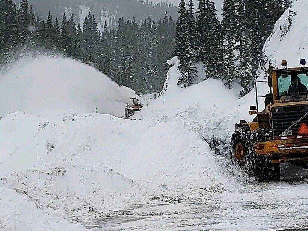
A federal snow-forecasting program, to be updated under a bill from Republican U.S. Rep. Jeff Hurd, won approval in the House on Wednesday.
HR 3857, which amends the Snowpack Water Supply Forecasting Reauthorization Act, is Hurd’s second bill to pass the U.S. House. The measure, adopted on a voice vote on Wednesday, now moves to the U.S. Senate.
Introduced on Sept. 10, H.R. 3857 drew two Democratic co-sponsors: Colorado Rep. Joe Neguse and Virginia Rep. Eugene Vindman.
Meanwhile, in the other chamber, Sen. John Hickenlooper is the sponsor of the bipartisan version there, introduced in July. It has not yet been heard by the Senate Energy and Natural Resources Committee.
In a statement, Hurd said the bill reauthorizes and updates the Snow Water Supply Forecasting Program to “incorporate modern technologies, including LiDAR and satellite imagery, to improve the accuracy of snowpack and water-supply predictions.”
Advanced tools authorized by the bill can “produce three-dimensional models of snowpack conditions, enabling water managers to better anticipate spring runoff and make more informed decisions about water storage and distribution,” he said.
The original, adopted by Congress in 2020, was designed to improve snowpack measurement in particular watersheds.
Neguse and Colorado U.S. Rep. Diana DeGette were among its original co-sponsors.
Accurate snow forecasting is critical for agriculture, recreation and municipal water systems. It assists with irrigation planning, drought management and annual water allocation.
The reauthorization includes $15 million for implementation between 2022 and 2026, and $6.5 million annually from 2027 through 2031.
Both the 2020 bill and the 2025 reauthorization included a requirement that the U.S. Bureau of Reclamation produce a report listing the basins and sub-basins where the modeling technologies are being used, along with outcomes and the participating partners and the Federal agencies involved.
One technology, known as “terrestrial laser scanning,” captures exact measurements of the surrounding ground surface elevation. It’s used to understand fine-scale snow processes, such as wind-drift snow and scouring, which is frozen snow that has been “scoured” to a hard surface.
According to the Bureau’s 2021 report, the technology has been used at Grand Mesa and previously in avalanche forecasting at Arapahoe Basin.
In his statement, Hurd said, “We cannot manage what we cannot measure. Water is life in the West, and accurate data is how we manage it.”
He added that families, ranchers, and water managers in his district “make critical decisions every day based on snowpack forecasts,” and that the bill will provide them with better tools and more reliable information.
Neguse called Wednesday’s House passage a “crucial step to improve forecasting and available data for snowpack and water supply monitoring.”

Hickenlooper primary challenger Julie Gonzales endorsed by national progressive group Indivisible
Ernest Luning
ernest.luning@coloradopolitics.com
Updated 1 hour ago
State Sen. Julie Gonzales’ bid to challenge U.S. Sen. John Hickenlooper in Colorado’s Democratic primary got a boost Tuesday from Indivisible when the national arm of the progressive grassroots group endorsed the Denver lawmaker. The national group’s endorsement comes less...

Trump switches endorsement back to Jeff Hurd, says Hope Scheppelman is ending run in Colorado’s 3rd CD
Ernest Luning
ernest.luning@coloradopolitics.com
Updated 10 hours ago
In a surprise twist, President Donald Trump on Friday said he is again endorsing Republican U.S. Rep. Jeff Hurd after pulling his support from the Grand Junction Republican last month and instead backing his primary challenger in Colorado’s 3rd Congressional...

Democrat Matt Cavanaugh ends campaign in Colorado’s 5th CD, says petition firm came up short
Ernest Luning
ernest.luning@coloradopolitics.com
Updated 5 days ago
Democratic congressional candidate Matt Cavanaugh said Wednesday that he was ending his bid to challenge Republican U.S. Rep. Jeff Crank in Colorado’s 5th District because the firm his campaign hired to gather petition signatures failed to deliver. Cavanaugh, an Army...

DeGette challenger Melat Kiros trounces 15-term Democratic incumbent in Denver delegate vote
Ernest Luning
ernest.luning@coloradopolitics.com
Updated 1 week ago
The 28-year-old, first-time candidate challenging Democratic U.S. Rep. Diana DeGette in this year’s primary soundly defeated the 15-term incumbent in a delegate preference poll conducted Saturday at a county party assembly in Denver. Melat Kiros, the daughter of Ethiopian immigrants...

Army veterans Jessica Killin, Joe Reagan qualify for Democratic primary ballot in Colorado’s 5th CD
Ernest Luning
ernest.luning@coloradopolitics.com
Updated 1 week ago
Democratic congressional candidates Jessica Killin and Joe Reagan secured spots Saturday in Colorado’s June primary to decide who will run against Republican U.S. Rep. Jeff Crank in a district that’s only ever sent GOP lawmakers to Congress. The two Democrats,...

Boebert challenger Eileen Laubacher joins lawsuit aimed at blocking her from Democratic assembly
Ernest Luning
ernest.luning@coloradopolitics.com
Updated 2 weeks ago
A Denver District Court judge on Thursday permitted Democratic congressional candidate Eileen Laubacher to join a lawsuit filed by one of her primary opponents seeking to prevent Laubacher from participating in the party’s assembly process in a bid to qualify...
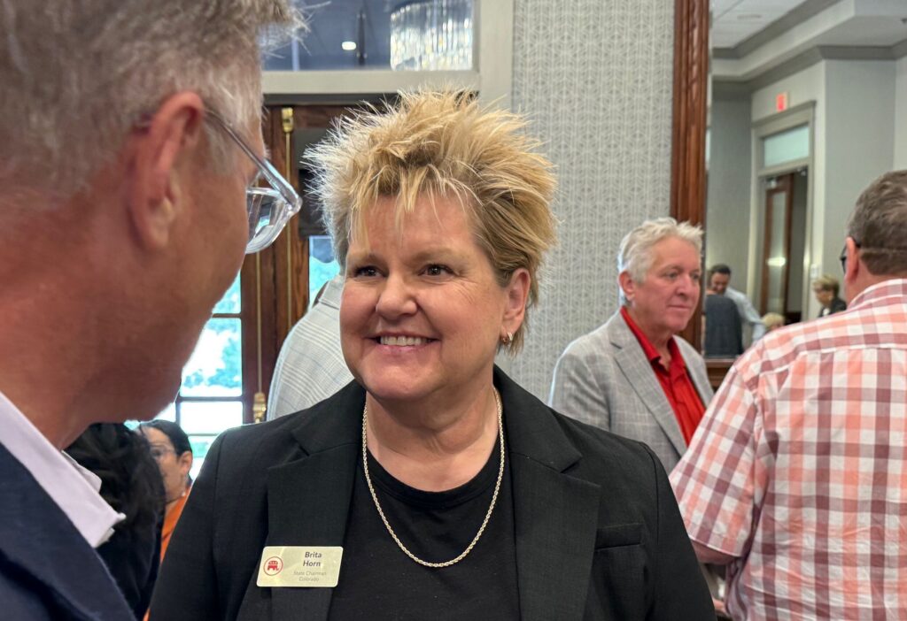
Colorado GOP chair Brita Horn says she’ll resign next month, points to ‘divide within our party’
Ernest Luning
ernest.luning@coloradopolitics.com
Updated 2 weeks ago
Colorado Republican Party Chair Brita Horn said Thursday that she will resign her position next month following the GOP’s state assembly, citing what she described as an “enduring divide” within the party “marked by vitriol and hostility.” Horn’s announcement came...

Republican Jeff Crank, Democrat Jessica Killin qualify by petition for Colorado’s 5th CD primary
Ernest Luning
ernest.luning@coloradopolitics.com
Updated 2 weeks ago
Republican U.S. Rep. Jeff Crank and Jessica Killin, one of the Democrats challenging the first-term incumbent, have both qualified for the primary ballot in Colorado’s 5th Congressional District after turning in a sufficient number of petition signatures, state election officials...

Can deliberation save democracy? | Vince Bzdek
Vince Bzdek
vince.bzdek@gazette.com
Updated 2 weeks ago
In September 2019, 523 Americans traveled to Dallas for an experiment called “America in One Room.” The gathering was designed to test a theory: Could representative citizens deliberate productively even in an era of intense polarization? The event focused on...
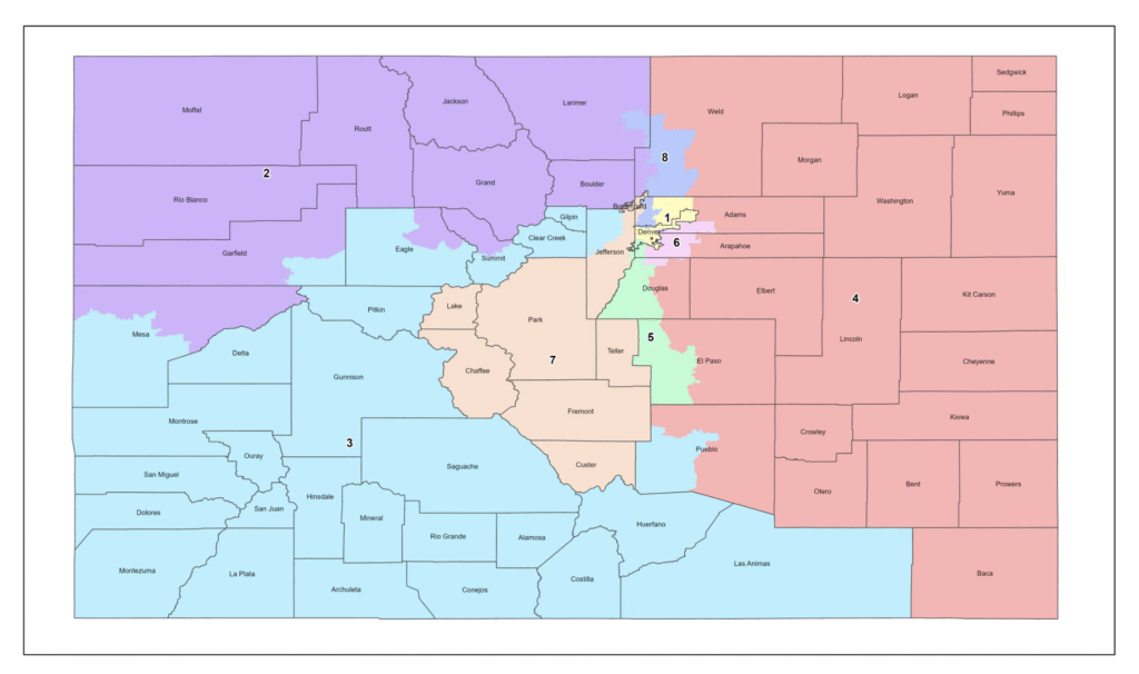
Redistricting scheme would give Colorado Democrats seven House members, split El Paso County | Bob Loevy
Bob Loevy
bob-loevy@coloradopolitics.com
Updated 2 weeks ago
A proposed redistricting plan, which could give Colorado seven Democratic members of the U.S. House of Representatives and only one Republican, would split El Paso County into two parts and thereby weaken the county’s influence in Congress. El Paso County,...
PREV
PREVIOUS

Colorado aims to close talent gap with new workforce development agency, initiatives
Colorado’s education leaders and legislators are planning changes to the state’s workforce development programs – including the creation of a new state agency – to help more students earn college degrees, certifications and apprenticeships. Gov. Jared Polis, House Speaker Julie McCluskie and Sen. Jeff Bridges joined representatives from state agencies, universities, and apprenticeship programs to […]

Family files lawsuit over 2023 Jeffco inmate death
The family of 27-year-old Ashley Jo Raisbeck filed a lawsuit against the Jefferson County Sheriff’s Office nearly two years after the woman died in custody. Jaime Raisbeck, Ashley’s mother, stood outside of the Alfred A. Arraj Courthouse Wednesday morning, a line of family holding memoriam signs behind her. “I don’t want another parent in my […]