

Redistricting dilemma: County commission explores ways to consolidate ‘communities of interest’, including southeast Colorado Springs (copy)
In response to heavy public support for racial and ethnic minority-populated areas holding greater weight when redrawing commissioner district boundaries, the El Paso County Redistricting Commission has presented new maps as it nears the end of its public input process.
Over the course of their last two meetings, held in Districts 4 and 3 on July 6 and on Monday, respectively, commissioners also addressed public challenges to the wildland-urban interface, where wildfire-prone areas meet residential development, as a prioritized community of interest.
The redistricting commission, consisting of the current five members of the El Paso County Board of Commissioners, is tasked with redrawing their constituent districts for the first time since 2017 and has until the end of September to do so.
Under House Bill 21-1047, passed in 2021, counties cannot see more than 5% in population deviation between their most and least populous districts. The bill also encourages, as much as possible, preserving “communities of interest – such as urban, rural or trade areas, or other factors like education, environment or water needs – to ensure “fair and effective representation.”
At each of the four public redistricting meetings held so far, residents from every district have advocated repeatedly for southeast Colorado Springs to be consolidated into one district so as to not dilute voting power.
“This (region has) a cohesive cultural and political identity, and also is the part of the county with the highest density of people from historically underrepresented groups, like Black, Latino and Hispanic residents,” state Rep. Tony Exum Sr., who represents House District 17 and much of southeast Colorado Springs, said on July 6.
Residents have defined that region as a group of just under 30 voter precincts west and northwest of the Colorado Springs Airport that each have a minority population of 45% or greater.
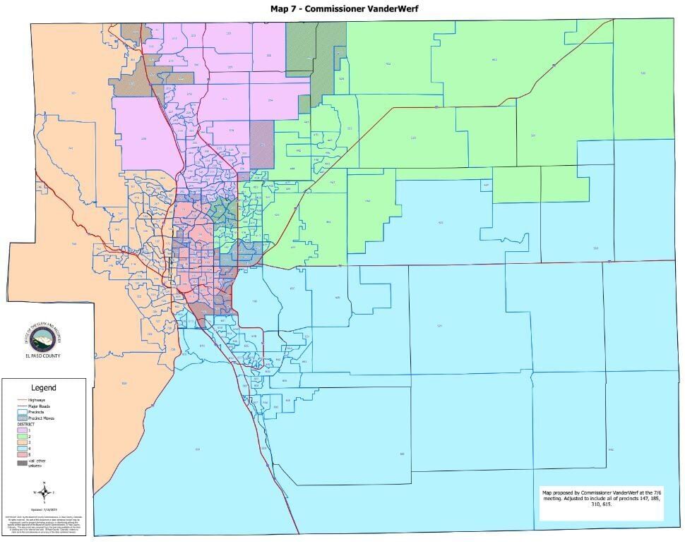
This week, commissioners reviewed a map proposed by District 5 Commissioner Cami Bremer that moved District 5’s boundaries north to consolidate its southeast precincts into District 4 as a cohesive community. They also reviewed a map proposed by District 3 Commissioner Stan VanderWerf that kept the Air Force Academy in District 1 and moved some of the Patty Jewett neighborhood into District 3 to consolidate southeast precincts into District 5.
But because populations grow more compact closer to Colorado Springs, the move to consolidate the southeast in Bremer’s map would require the entire part of the Eastern Plains, from near Black Forest to Pueblo County, to have just one commissioner.
Moving even a few precincts in central Colorado Springs could affect close to 35,000 residents, El Paso County Clerk and Recorder Steve Schleiker said, a significant effect when each new district should have a population of roughly 146,550, based on 2020 U.S. Census data.
That kind of give-and-take is difficult to navigate, commissioners have argued, and the task of keeping all of the vast number of possible communities of interest in the county together is “impossible.”
Residents on Monday argued against consolidating Monument and southwest Colorado Springs into one district, questioning whether wildfire-fighting needs and efforts west of Interstate 25 are truly affected by sharing a single commissioner.
Previously, District 1 Commissioner Holly Williams has questioned prioritizing the wildland-urban interface when HB 21-1047 emphasizes political competitiveness and compliance with the Voting Rights Act of 1965, or protecting ethnic minority communities.
“I was the one who initially brought up the WUI (as) a good dividing line,” Williams said at the July 6 meeting. “I just wonder if we should be placing so much emphasis on … because we have a very specific list of communities of interest listed in this House bill.”
District 3 residents argued that the small business- and tourism industry-saturated westside, heavy with historic districts, should be kept separate from Monument, and argued against any map that decreases competitiveness in District 3 – which VanderWerf narrowly won after a late push by his Democrat opponent in 2016.
“We’re not asking to hand a district to the Democratic Party … what we’re asking is that you do not continue to pull away the chance that Democrats have of winning, that’s it,” resident John Jarrell said. “Then, they’ll have to do the hard work of actually winning the elections.”
The next redistricting meeting will be held Monday at 9 a.m. at the county Regional Development Center.
County staff did not eliminate any new maps, but will present a total of 16 proposed maps available for public viewing at the next redistricting meeting, including two maps created by residents Katherine Czukas and Lois Landgraf.
Commissioners are expected to adopt a final map on Aug. 15.
Click or tap here for political competitiveness and racial population analysis of the proposed maps from the July 6 meeting.
Click or tap here for political competitiveness and racial population analysis of the proposed maps from Monday’s meeting.
More information on the county Redistricting Commission, how to create and submit redistricting map proposals and further resources can be found here.
City Council to hear plans for 400-unit apartment project near South Nevada in Colorado Springs
The clock is ticking: Negotiations stall on Colorado River water-sharing pact
Marianne Goodland
marianne.goodland@coloradopolitics.com
Updated 9 hours ago
With a critical Nov. 11 deadline fast approaching, negotiators from the seven Colorado River basin states remain at odds over how to manage a river that serves 40 million people — and which, experts long agree, is overallocated. Negotiations are...

Museum’s ‘Passport to Play’ was both fun and profitable | NONPROFIT REGISTER
Joanne Davidson
joanne-davidson@coloradopolitics.com
Updated 14 hours ago
CHILDREN’S MUSEUM OF DENVER AT MARSICO CAMPUS Denver News: His role as president and chief executive officer of the Children’s Museum of Denver at Marsico Campus requires Mike Yankovich to wear many hats: exhibit developer, growth and innovation catalyst, number-cruncher,...
CPW fires ranger allegedly involved in stabbing hoax at state park
Spencer McKee
spencer-mckee@coloradopolitics.com
Updated 17 hours ago
On Aug. 19, seasonal park ranger Callum Heskett, 26, is said to have reported that he had been stabbed by an attacker at Colorado’s Staunton State Park. Callum was transported to a local hospital with a serious torso injury, with...

Israel bombs another Gaza City high-rise as US advances a new ceasefire proposal
Wafaa Shurafa
wafaa.shurafa@associatedpress.com
Updated 4 days ago
DEIR AL-BALAH, Gaza Strip (AP) — Israel struck and destroyed another high-rise building in Gaza City on Monday after warning residents to evacuate, part of an offensive aimed at taking over the largest Palestinian city. The military said it was...

Ballot measure seeks tax hike for higher income earners in 2026
Marianne Goodland
marianne.goodland@coloradopolitics.com
Updated 1 week ago
A coalition led by a Colorado think tank will file a ballot initiative on Wednesday to raise state income tax rates on annual household incomes and corporations with earnings above $500,000. The ballot measure, which sets up a “graduated” income...

Colorado Democrats blast Trump’s decision to relocate Space Command as a ‘nakedly political move’
Ernest Luning
ernest.luning+co@coloradopolitics.com
Updated 1 week ago
Leading Democratic officials in Colorado on Tuesday ripped President Donald Trump’s announcement that the U.S. Space Command will move from Colorado Springs to Huntsville, Alabama, as a politically motivated decision meant to reward Republican friends while putting the nation’s military...

Trump says he will order federal intervention in Chicago and Baltimore despite local opposition
Associated Press
associated-press@coloradopolitics.com
Updated 1 week ago
WASHINGTON (AP) — President Donald Trump said Tuesday that he will direct federal law enforcement intervention to Chicago and Baltimore, despite local officials in both places opposing such moves. Asked by reporters in the Oval Office if he had decided...
Tech group lauds move to delay new AI regulation
Luige Del Puerto
luige-del-puerto+copo@coloradopolitics.com
Updated 2 weeks ago
A technology trade group on Tuesday lauded a move by the Colorado Senate to delay the implementation of new artificial intelligence regulations originally set to take effect early next year. Under the proposal approved by senators yesterday, the new implementation...

Feds OK expansion of mine that supplies coal to Montana’s largest power plant | OUT WEST ROUNDUP
Associated Press
associated-press@coloradopolitics.com
Updated 3 weeks ago
MONTANA Feds OK coal mine expansion The federal government has authorized a nearly 1,900-acre expansion of the mine that supplies Montana’s largest power plant with coal. The Office of Surface Mining Reclamation and Enforcement announced on Aug. 6 that it...
Gov. Polis unveils new Colorado River information hub at annual Water Congress
Eugene Buchanan
eugene@paddlinglife.com
Updated 3 weeks ago
Colorado Gov. Jared Polis opened the 2025 Summer Colorado Water Congress Conference at the Steamboat Grand Hotel by unveiling a new information site and leading a panel on federal water funding and wildfire impacts. Speaking to a packed Grand Ballroom,...
PREV
PREVIOUS

Colorado officials eye new reservoir for native trout
Colorado Parks and Wildlife has identified a new home for a native fish. Officials recently announced work would begin late this month to prepare Rito Hondo Reservoir for Rio Grande cutthroat trout. In a news release, CPW called it “a unique opportunity” while the reservoir near Creede has been lowered for dam repairs. According to […]

Mobolade gives progress report, teachers union names 6 lawmakers 'top of class' | WHAT YOU NEED TO KNOW
Today is July 20, 2023 and here’s what you need to know: On Wednesday, his 44th day as Colorado Springs mayor, Yemi Mobolade delivered a progress report on goals he laid out seven weeks ago in a “blueprint” guiding his first hundred days in office. He met with members of the local media at his […]