U.S. Forest Service announces closure of Waldo Canyon area until 2029
The U.S. Forest Service signed an order Tuesday announcing the closure of the Waldo Canyon burn area until June 2029.
The Waldo Canyon fire was one of the largest national disasters in state history, resulting in two deaths. Before being contained July 10, 2012, the fire caused over 32,000 evacuations, the loss of over 18,000 acres of land and the destruction of nearly 350 houses.
Trails and Open Space Coalition Executive Director Susan Davies says this order is not new, but simply a renewal of the closure that has been in place since the fire.
“Most of us don’t really think that’s a much of a big deal,” Davies said. “It’s just that they have to put the notice back out.”
The order states that being on the trail, camping, building or using a campfire and using any type of motor vehicle in the described areas in the Waldo Canyon burn area is prohibited.
The described area is defined as the National Forest Service lands north of U.S. 24 in El Paso County within the following boundaries:
• Beginning at the western edge of the Forest Service boundary in Section 5, Township 13 South, Range 68 West, 6th P.M.
• East following Forest Service Road 300 M to its junction with NFSR 300 and then across NFSR 300 and continuing south of NFSR 306 across the Rampart Reservoir dam.
• East to the private property boundary in Section 25.
• South along the same private property to Monument Creek.
• East along the southern edge of Monument Creek to the eastern edge of the Forest Service Boundary at the northwest corner of Section 33 and south along the eastern NFS Boundary.
• West along the NFS Boundary and ending at the western edge of the NFS Boundary in Section 5.
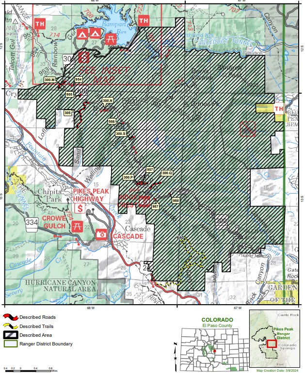
The shaded area outlines the described area that is now prohibited to be on until June 2029.
Courtesy of U.S. Forest Service

The shaded area outlines the described area that is now prohibited to be on until June 2029.
Roads in the area include the following NFS roads:
300.M
955
305
300.N
956
300.S
957
300.P
300.Q
87
988
The trail in the area is Forest Service Trail 640, Waldo Canyon Trail.
People exempted from the order are those with a Forest Service permit or any federal, state and local officers, including firefighters.
The goal of the closure is to protect natural resources and public health and safety due to impacts of the Waldo Canyon fire back in 2012.
Before the pandemic, public input was sought regarding what to do with the land post-fire, as the area was wildly popular with locals and visitors before the fire.
Outdoor enthusiasts asked to think big in re-imagining post-fire Waldo Canyon
“We’d love to see it reopened, obviously, but the only way that’s going to happen is if a trailhead is created and they can get in there and allow people back in there,” Davies said.
“That’s the whole goal of the Black Canyon quarry that the city purchased.”
The hope it to turn that space into a trailhead, among other uses, and partner with the Forest Service to connect and reopen the original trail.
However, this process will take several years, and the city is only in the first steps starting with plans to improve the vegetation within Black Canyon quarry.
“It’s a partnership, and it’s just something that takes a really long time,” Davies said.
Year after quarry bought for return to Waldo Canyon, reclamation yet to begin
The renewed order went into effect at 12:01 a.m. Wednesday and lasts until June 30, 2029, unless rescinded.
A violation of the above prohibitions is punishable as a Class B misdemeanor by a fine of not more than $5,000 for individuals and $10,000 for organizations, or by imprisonment for not more than six months, or both.


